Community Corner
Sandy Strike a Matter Of When Not If, Official Says
Storm regained hurricane strength early Saturday morning and is predicted to not lose steam when it makes landfall.

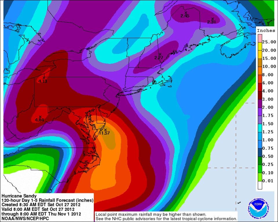


The National Oceanic and Atmospheric Administration's updated storm path and rainfall projections show show options for the storm missing the region "rapidly dwindling."
According to the report and graphics released Saturday evening by the NOAA's Gary Szatkowski, confidence continues to increase that the region will see very severe impacts from this storm.
Impacts could include:
Find out what's happening in Waynewith free, real-time updates from Patch.
• Strong damaging sustained winds 35 to 50 miles per hour over a prolonged period of time (24 to 48 hours), with gusts up to near hurricane strength. Strongest winds are expected south and east of the I-95 corridor.
• Extremely heavy rainfall.
• Major to record inland flooding along streams and rivers.
• Major to record coastal flooding, exacerbated by the full moon on Oct. 29.
Szatkowski's report also said the focus of preparation efforts should be on when Sandy hits the region, not if Sandy hits the region.
Find out what's happening in Waynewith free, real-time updates from Patch.
Saturday afternoon the National Weather Service (NWS) said Hurricane Sandy is not expected to gain or lose strength in the next 48 hours, according to its Saturday afternoon statement.
Meterologists at the NWS predicted Saturday sustained winds of 75 miles per hour with larger gusts possible when Sandy makes landfall on Monday.
Early Saturday afternoon meterologists pinned Hurricane Sandy to a southern or central New Jersey landfall, according to a report from AccuWeather.
The storm is expected to arrive Monday evening, but AccuWeather meterologists said that the worst of the storm will occur ahead of its center.
Sandy regained hurricane strength Saturday morning as weather forecasters predict it will turn into a destructive "superstorm" and up the Eastern Seaboard that could cause as much as $3.2 billion in damages, CNN.com reported.
NWS said in an alert Sandy, which was briefly downgraded early Saturday morning to a tropical storm, is forecast to move Northeast and remain off the North Carolina coast, resulting in “significant impacts” along that state’s coast, before it continues to move north.
An NWS forecast for the greater New York City and Philadelphia area states that the storm is expected to “become a powerful, faster moving cyclone as it turns northwest ashore somewhere into New Jersey Tuesday.”
CNN’s Weather Unit expects Sandy to merge with a strong cold front from the west and morph into a “superstorm” that could cause widespread power outages for the East Coast from North Carolina to Maine.
The state Department of Environmental Protection ordered the floodgates on the Pompton Lakes dam to be raised in anticipation of the storm's arrival.
Get more local news delivered straight to your inbox. Sign up for free Patch newsletters and alerts.


